There are three undersea features in the waters associated with Pratas Island: Pratas Atoll, North Vereker Bank and South Vereker Bank.[1]: 8, 9 [29][30][31] The atoll is circular, and the crescent-shaped Pratas Island occupies its western part. Below the ocean's surface[32] to the northwest (21°N116°E / 21°N 116°E / 21; 116) of Pratas Island, North Vereker Bank rises to 11 metres (36 ft) below sea level and South Vereker Bank to 58 metres (190 ft) below sea level.[14]: 6
Map of Pratas Island (NAVOCEANO, 1969)Stele erected on Pratas Island by the ROC Ministry of the Interior (Translation: Barrier of the South China Sea)USS Frank Knox aground on Pratas Reef 1965South China Sea
The English name of the island derives from the PortugueseIlhas das Pratas ("Silver Plate Islands"), which was given to the atoll in the 16th century owing to its round shape.[citation needed][34] Pratas Atoll is also called Pratas Reef.[35]
The East IndiamanEarl Talbot was wrecked on Pratas Island on or about 22 October 1800 with the loss of all aboard. At the time the island was known to British sailors as "Perates". In 1851, the British screw sloopHMS Reynard wrecked on the south-east bend of Pratas Atoll while going to the aid of another wrecked vessel; the crew were all saved.[43] Decades later, the boilers and parts of the machinery of the wreckage of HMS Reynard remained visible on the atoll.[44]
In 1859–1861, there was a correspondence between the British Colonial Office and the Hong Kong colonial authorities about building a lighthouse on the main island on the atoll. Despite an offer by a British businessman in Xiamen (Amoy) to build it, it was decided that the cost was too great and the matter lapsed. It is clear from the correspondence that no one supposed the atoll to be a part of any known jurisdiction, so negotiations might have been required to ensure that any construction would be legal.[45]
One consequence of that initiative was that, in 1858, the Royal Navy survey ship HMS Saracen completed the first detailed survey of the atoll, resulting in the Plan of the Pratas Reef and Island, J. Richards and others, April 1858, being published by the British Admiralty.[46] On the resulting chart three positions are proposed for a lighthouse: on Pratas Island, on the north-east corner, or on the southern edge near where HMS Reynard had stranded. In the north-east corner of the lagoon the chart notes "Anchorage for junks", indicating regular use by fishing and other small vessels taking shelter. The chart's rubric noted that the available safe draft for vessels entering was only 15 feet (4.6 m), so it was restricted to relatively small vessels only.
In 1908–1909, a Japanese businessman named Nishizawa Yoshizi (西澤吉次) established a guano collecting station. He destroyed the Dawang Joss House (大王庙), dug up graves and poured the bone ashes of Chinese fishermen into the sea, and renamed the atoll "Nishizawa Island".[48][49] After a diplomatic confrontation, Chinese sovereignty was re-established, and Nishizawa withdrew, after being compensated by the Guangdong provincial government, and after paying compensation for the destruction of a Chinese fishermen's shrine.[50]
In December 1930, the schooner Hedwig (Netherlands) ran aground on a coral reef off Pratas Island and was wrecked.[51][52]
Japanese naval personnel occupied Pratas Island during World War II. The Japanese Navy used the island as a weather station and listening post. On May 29, 1945, at 10:22 AM, a landing party consisting of Australian commandos and US naval personnel from the submarine USS Bluegill raised the US flag, declared the island a United States territory, and named it Bluegill Island. The landing party destroyed a radio tower, weather station, fuel and ammunition dumps, and several buildings. They encountered no resistance because the Japanese had left the island prior to the arrival of Bluegill.[54][55][56]
On 6 June 1949, the ROC established the Hainan Special Administrative District (海南特別行政區), which included Pratas Island.[24][25]
In autumn 1954, the senior ROC politician Chiang Ching-kuo visited the island and made an inspection.[24]
On 9 June 1960, during Typhoon Mary, the Hong Kong cargo ship Shun Lee was driven against Pratas Reef and wrecked. Her 55 crew took to the liferafts and were rescued by the USS Yorktown (CV-10).[58][59]
While underway in the South China Sea on 18 July 1965, the USS Frank Knox ran aground on Pratas Reef, and was only freed on 24 August after a very difficult salvage effort.[60][61]
On 13 April 1996, the jurisdiction of the Taiwan Kaohsiung District Court was extended to include Tungsha Island (Pratas Island).[23]
In May 1999, Kaohsiung Mayor Frank Hsieh visited the island and hung an address plate on the island’s fishing service station.[62] On 21 December 2000, ROC President Chen Shui-bian visited the island with Kaohsiung Mayor Frank Hsieh.[63][20] On 28 July 2005, President Chen Shui-bian again visited the island and inaugurated the Fifth Maritime Patrol Squad of the Coast Guard Administration.[20]
In January 2007, the ROC government designated the Pratas atoll as the Dongsha Atoll National Park, the first marine national park in Taiwan.[64]
On 8 January 2013, an office of Chunghwa Post was established on Pratas Island.[65]
In September 2020, the PRC conducted air drills over the waters between the main island of Taiwan and Pratas Island that intruded into the ROC air defense identification zone (ADIZ). The planes were issued radio warnings by the ROC military until they left.[15]
On 15 October 2020, a regular civilian charter flight by Uni Air had to abandon its trip from the main island of Taiwan to Pratas Island when Hong Kong air traffic controllers told the captain of the aircraft that there were "dangerous activities" happening below 26,000 ft (7,900 m) and that the Uni Air aircraft could not enter the Hong Kong Flight Information Region (FIR). The transcript of the conversation between the pilot and air traffic control was released by the ROC Civil Aeronautics Administration.[2][10][66][67][68][69] The next day, the ROC Minister of National Defense Yen Teh-fa called on PRC not to "disrupt the order of international aviation".[70][71] On 20 October, Deputy Chief of the ROC General Staff, Lieutenant-General Li Ting-sheng (李廷盛), visited Pratas Island. He made an inspection of the living facilities of the military personnel and gave them instructions.[72] On 26 October, the same Uni Air aircraft made the round trip flight between the main island of Taiwan and Pratas Island.[73][74]
On 27 October 2020, a Y8 PRC military aircraft entered ROC air defense identification zone (ADIZ) between the main island of Taiwan and Pratas Island for the twenty-first time that month.[75] On 28 October, Zhu Fenglian of the Taiwan Affairs Office of the PRC was asked whether, in light of PLA military exercises in Fujian and Guangdong, there was or was not a plan to take Pratas Island from the ROC. Feng responded that she did not have to answer hypothetical questions.[76][77] On 2 November, eight Chinese PLAAF aircraft breached the ROC ADIZ above an area of sea near Pratas Island.[78] On 3 November, Y-8 plane entered the ADIZ of the ROC in the area between the main island of Taiwan and Pratas Island.[79] On 4 November, the ROC Minister of National Defense, Yen Teh-fa, stated in a legislative hearing that since January 2020, 276 PRC military planes had entered the airspace between the main island of Taiwan and Pratas Island, activity that Yen associated with plans by the PRC for a creating its own ADIZ in the South China Sea.[66][80] On 6 December, a PRC air force Y-8 plane entered the Taiwan ADIZ between the main island of Taiwan and Pratas Island, the fifth day in December that PRC military aircraft entered Taiwan's ADIZ.[81]
Geography
Map showing the location of Pratas Island (within (VH)R7) in the South China Sea (DMA, 1984)Map of Tung-sha Tao (Pratas Island) (NAVOCEANO, 1969)Map including Pratas Reef, Pratas Island and surrounding region from the International Map of the World (AMS, 1965)Map including Pratas Island (within VHR7) (NIMA, 2000)
Pratas Island is located 444 km (276 mi) from the rest of Kaoshiung,[62] 850 kilometres (530 miles) southwest of Taipei, 320 kilometres (200 miles) southeast of Hong Kong[8] and 260 km (160 mi) south of Shantou, Guangdong[31] in the northern part of the South China Sea (20°43′N116°42′E / 20.717°N 116.700°E / 20.717; 116.700). An international team of researchers conducted a comprehensive population genetic analysis of 11 marine species sampled from the island. They concluded that Dongsha Atoll is an important regional stepping-stone that promotes genetic connectivity among South China Sea reefs, as marine larvae can potentially reach a large number of reefs in the northern South China Sea.[82] The protection of the island and surrounding reefs by the Taiwanese government as Dongsha Atoll National Park may therefore benefit the entire region.
Pratas Island is 2.8 km (1.7 mi) long and 0.865 km (0.537 mi) wide; it is the only feature of the group above sea level. The island is made up of coral atolls and reef flats. Brush, vines and bushes cover some of the island - the rest is white sand. Flora and fauna on and around Pratas Island include:[citation needed]
In the Journal of Science (April 1867) there is a nine-page article entitled "The Natural History of Pratas Island in the China Sea" by Dr. Cuthbert Collingwood, the naturalist on board HMS Serpent. It describes what was observed, especially bird life, during a visit of two days while the survey ship lay at anchor. Collingwood explored the island on 30 April 1866.[47]
The Vereker Banks (21°N116°E / 21°N 116°E / 21; 116) are 74 km (46 mi) northwest of Pratas Atoll.[83] North and South Vereker Banks are under water.[32] North Vereker Bank (北衛灘[84]) rises to 11 metres (36 ft) below sea level with an average depth of 60 metres (200 ft) to 90 metres (300 ft) below sea level. A well head with a depth of 4.1 metres (13 ft) lies 30 metres (98 ft) off North Vereker Bank. Two to three miles of deep water separate North Vereker Bank and South Vereker Bank. South Vereker Bank (南衛灘[84]) rises to 58 metres (190 ft) below sea level. A well head, in a depth of over 100 metres (330 ft), lies 28 mi (45 km) north of the Vereker Banks at 21°38′N116°03′E / 21.633°N 116.050°E / 21.633; 116.050. The associated production platform and SPM make up Lu Feng Terminal; the terminal is enclosed by a restricted area. Exploration for oil is taking place in this area.[14]: 6
There are also some seamount formations nearby which are not part of the three atolls:[citation needed]
Jianfeng Seamount (尖峰海山)
Maojia Seamount (芼架海山)
Beipo Seamount (北波海山)
Politics and government
The island is part of the Republic of China (Taiwan) with the postal code 817. Although there are no long-term inhabitants on the island, Pratas is administered by the Kaohsiung City Government under Cijin District (Qijin). The island has been uninhabited, yet nations (including China and Japan) have claimed them to be their overseas territory.
Military
As of November 2020[update], about five hundred Taiwanese marines were stationed on Pratas Island. The island has a network of underground bunkers.[85] According to regulations updated on December 2, 2020, in the event that communication is cut off between mainland Taiwan and Pratas Island or Taiping Island (Itu Aba), the highest-ranking local officer can make the decision to fire back at assailants.[86]
According to an anonymous PLA source, plans created around 2010 by China for an air defence identification zone in the South China Sea include Pratas Island airspace.[87] The PLA's actions near the southwest corner of the Taiwan ADIZ and Pratas Island in late 2020 led to speculation that the area might be declared part of an ADIZ by China.[80][88][89]
In the later half of 2020, repeated reports of Chinese military exercises and fly overs near the island were interpreted as an apparent attempt to cut off the supply line between Pratas Island and mainland Taiwan.[90]
Pratas Island settlement
As an island with no permanent inhabitants, it is visited largely by fishermen, military personnel and researchers. Amateur radio operators participating in the DXCC and Islands on the Air awards programs also visit occasionally.[91]
In 1954 the ROC Government personnel stationed on Pratas erected a stone tablet on the southern side of the island, facing the ocean.[92]
The Da Wang temple is dedicated to 'Kuang Kang' and 'The South China Sea Goddess' - Mazu. It is said[by whom?] that the statue of Guan Gong came to Pratas Island on a canoe in 1948. The soldiers on Pratas Island built a temple to worship her in 1975. Today,[when?] the canoe is still kept in the temple. The joss sticks and candles are donated by soldiers, as was the golden sign hung in front of the statue. There is an 'Ever Green' pavilion in front of the temple which was also built by the soldiers. It is the most verdant place on the island.[92]
The Minister for Internal Affairs of the ROC erected the South China Sea Defense stone tablet to declare Republic of China sovereignty in 1989.[92]
In July 1991 the Kaohsiung City Government erected the Pratas Island measuring memorial stone tablet as a symbol that Pratas Island falls within the jurisdiction of Kaohsiung City.[92] Within Kaohsiung, the island belongs to Cijin District (Qijin).
The ROC Government established the Triangulation Benchmark as the triangulation point for Pratas Island in December 1991. There are words on each side of the base of the triangulation point stone tablet. They read 'The Pratas Triangulation Point' on the front, and 'Longitude: 116o 43" 42.5601'E, Latitude: 20o 42' 6.2415'N, Height: 2.4875 meters.' The words 'Defend the South China Sea', written by the commander, Lo Ben Li, were also engraved on the stone tablet. The National Tsing Hua University webpage about the island states: "In addition to making it more convenient to survey and draw navigational maps, and to construct and develop facilities on the island, the establishment of the triangulation point is also the basis of our sovereign rights."[92]
Public buildings
Hospital, 2004
The library is located on one side of the main plaza, and is the center for soldiers to obtain spiritual nourishment. The library contains more than two thousand books.[92]
The military post office is Office No. 67. The Ministry of Transportation and Communications issued the 'South China Sea Islands Map Stamps' in 1996, as a set of two stamps. The inscription 'South China Sea Defense' from the national stone tablet on Pratas Island was printed on the five-dollar stamp, and the 'Defend the South China Sea' inscription from the national stone tablet on Taiping Island was printed on the seventeen-dollar stamp. The background was the south China coastline, Taiwan and Hainan Island with the blue sky and sea. This was the first time that the ROC had issued stamps with the theme of the South China Sea.[92]
In 1987 the military and civilian occupants built the 'Pratas Fishermen's Service Station'. The station was built in traditional Chinese courtyard house style, and provides convenient services for fishermen and boats in the South China Sea, insuring the fishermen's safety and upholding ROC sovereignty. The services provided include lodging, medical rescue, entertainment and supply. The station also provides lodging for the scientists who come to conduct research on the island.[92]
Diesel-fueled generators are used to power the island. In March 2016, a solar energy system built by the Coast Guard Administration went into operation. The system covers an area of 310.6 m2 and produces 53,200 kWh of electricity each year.[94]
Transportation
The Dongsha Island Airport features a runway located on the north end of Pratas Island with a small airport terminal at the eastern end. The airport is used by the ROC military. A main shack and subordinate shack are located on the southeast end of the island. There are no refueling facilities.
Two piers on the southeast shore allow for small watercraft to land.
A circle with a radius of 10 nmi (19 km) centered on Pratas Island, referred to as VHR7, is a prohibited area for aeronautical purposes. The 'VH' in VHR7 denotes 'Hong Kong' and the 'R' denotes a 'Restricted Area'.[37] Pratas Island and VHR7 are located within the Hong Kong Flight Information Region (FIR).[2][10][95]
Gallery
Pratas Island Lagoon
Airport
Pratas Island Beach
Southern edge of Pratas Atoll (Pratas Island can be seen in the distance)
^ abc"Limits in the Seas - No. 127 Taiwan's Maritime Claims"(PDF). United States Department of State. November 15, 2005. Archived(PDF) from the original on 15 July 2020. Retrieved July 1, 2012. The Pratas Reef lies 230 miles to the southwest of the southern tip of Taiwan.26 It consists of an island in the mouth of a semicircular shoal open to the west. The segments D1-D4 close the mouth by connecting the headlands of the shoal with the island.
^ abcDieter Heinzig[in German] (1976). Disputed Islands in the South China Sea(PDF). Harrassowitz. pp. 14, 19, 32, 56. ISBN3-447-01804-6. Archived from the original(PDF) on 22 January 2017. p.14: "Strictly speaking, only one of the four controversial archipelagos may truly be referred to as a group of islands: the Paracels. The Pratas consist of one island and two sands."
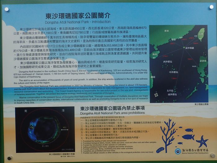
^ ab東沙環礁國家公園簡 [Dongsha Atoll National Park - Introduction]. Marine National Park Headquarters (海洋國家公園管理處) (in Chinese (Taiwan) and English). Archived from the original on 1 October 2020. 東沙環礁位於南海北部海域,東北距高雄450公里,西北距香港320公里,西南距海南島榆林670公里,南距南沙太平島1,190公里,東南離馬尼拉780公里;行政區域隸屬高雄市旗津區。{...}Dongsha Atoll located in the northern South China Sea is 450 km southwest of Kaohsiung, 320 km southeast of Hong Kong, 670 km northeast of [Yulin on] Hainan Island, 1,190 km north of Taiping Island, [and] 780 km northwest of Manila. Administratively, it is under the Cijin District of Kaohsiung.
^ ab"Law on the Territorial Sea and the Contiguous Zone of 25 February 1992"(PDF). Archived(PDF) from the original on 18 July 2004 – via United Nations. The PRC's territorial land includes the mainland and its offshore islands, Taiwan and the various affiliated islands including Diaoyu Island, Penghu Islands, Dongsha Islands, Xisha Islands, Nansha (Spratly) Islands and other islands that belong to the People's Republic of China
^ ab汕尾市. 广东省民政厅网站 (in Simplified Chinese). May 2005. Archived from the original on 3 November 2020. 城区{...}(东沙群岛不是镇建制)
^ ab广东省国土资源厅 (30 June 2018). 城区地图 (Map). Department of Natural Resources of Guangdong Province 广东省自然资源厅 (in Simplified Chinese). Archived from the original on 7 July 2020 – via Internet Archive. 东沙群岛{...}北卫滩{...}南卫滩{...}东沙岛{...}东沙礁
^ abcRichard Louis Edmonds (1992). Graham P. Chapman; Kathleen M. Baker (eds.). The Changing Geography of Taiwan, Hong Kong and Macau. The Changing Geography of Asia. Routledge. p. 160. ISBN0-415-05707-8. Since 1949, Taiwan has remained under Nationalist (Kuomintang) control ... In addition, the Nationalists maintain garrisons and weather stations in the South China Sea on T'ai-p'ing Island in the Nansha or Spratly Islands and in the Tungsha or Pratas Islands (see Figure 6.1).
^ abcd"History". Taiwan Kaohsiung District Court Republic of China. Archived from the original on 15 October 2011. Retrieved 21 July 2020.
^ abcd東沙島地方志資源調查委託辦理計畫 成果報告(PDF). Marine National Park Headquarters 海洋國家公園管理處 (in Chinese (Taiwan)). December 2008. p. 26. Archived(PDF) from the original on 9 July 2020. Retrieved 9 July 2020. 民國35年(1946年){...}9月,海軍負責接收東沙島,並設立東沙管理處;東沙氣象台由海軍負責管理。{...}民國43年(1954年){...}秋季,國防部長蔣經國至島上視察.
^ ab"Amid disputes, Taiwan highlighting South China Seas claims". AP News. March 23, 2016. Archived from the original on 27 May 2023."Taiwan also has complete control of the Pratas Islands, which it calls Dongsha, centered on an atoll in the northern section of the South China Sea about 340 kilometers (211 miles) southeast of Hong Kong. Taiwan has designated the area a marine national park, but still operates a small airport there, maintains a garrison and operates a fishing boat aid station. China also claims Pratas, but has made no moves to dislodge the Taiwanese presence."
^Note that Woody Island in the Paracel Islands has a land area of 210 ha, which is greater than Pratas Island's 240-64=176 ha. Also, the PRC's land reclamation activities during 2014 & 2015 have created an "island" of ~230 ha at Fiery Cross Reef.
^ ab"ENR 5 NAVIGATIONAL WARNINGS". Government of the Hong Kong Special Administrative Region of the People's Republic of China. Archived from the original on 2 November 2020. Retrieved 2 November 2020 – via Google Cache, Wayback Machine. VHR7 TUNGSHA (PRATAS) ISLAND Circle of 10 NM (18.5 km) radius centred at 2042N 11643E
^擬定連江縣風景特定區計畫說明書(PDF) (in Chinese (Taiwan)). June 2002. pp. 15, 16. Archived from the original(PDF) on 8 January 2020. 東引地區 (北固礁、東沙島、雙子礁){...}東引鄉 北固礁 0.2701 0.11 東沙島 5.0434 1.96
^ ab"Dongsha". National Parks of Taiwan. Retrieved 29 August 2020. This cross-domain cooperation effectively implemented the rat extermination program, and 721 mice were caught on the Dongsha Islands (Pratas Islands) in just one month.
^"HMS Reynard". William Loney website. Retrieved 8 February 2014.
^ abHuang Tzu-ti (18 May 2020). "Kaohsiung mayor may visit Dongsha Islands to assert Taiwan's sovereignty". Taiwan News. Retrieved 3 August 2020. Located 444 kilometers from Kaohsiung City, the Dongsha, or Pratas, Islands, consist of one island, two coral reefs, and two banks. The islands are administered by Kaohsiung's Cijin District, and Coast Guard personnel are stationed there. {...} Former Kaohsiung Mayor Frank Hsieh (謝長廷) made a visit to the Dongsha Islands in May of 1999 for the same purpose, when he hung an address plate on the island's fishing service station. Chen Chu (陳菊), his successor, never visited the islands during her 12-year stint.
^Anirban Bhaumik (14 November 2020). "India opposes China's move to set up Air Defence Identification Zone on South China Sea". Deccan Herald. Archived from the original on 14 November 2020. Retrieved 14 November 2020. Without mentioning China, he expressed India's concern over the nation's aggressive moves in the region, including building military infrastructures in the disputed waters, and purported plan to create an Air Defence Identification Zone (ADIZ) covering the disputed Pratas, Paracel and Spratly Islands.


)_Dongsha_Atoll_National_Park,_WEY,_10.jpg)