The provinces of Thailand are administrative divisions of the government of Thailand.[3] The country is divided into 76 provinces (Thai: จังหวัด, RTGS: changwat, pronounced[t͡ɕāŋ.wàt̚]) proper, with one additional special administrative area (the capital, Bangkok).[4][5][6] They are the primary local government units and act as juristic persons. They are divided into amphoe (districts) which are further divided into tambon (sub districts), the next lower level of local government.
All provinces form part of the partially devolved central government, or the regional government (ราชการส่วนภูมิภาค ratchakan suan phumiphak). Majority of public services, including police, prison, transport, public relation and others are still overseen and managed by the province on behalf of the central government. In 1938–1996, the Royal Thai Government proposed that each province should have a council, elected from people resided within that province. The council acts as an advisory and auditing body to the governor (ผู้ว่าราชการจังหวัด phu wa ratchakan changwat), who is appointed by the central government. In 1997, each province has its own provincial administrative organization (องค์การบริหารส่วนจังหวัด ongkan borihan suan changwat), presided over by the president. The PAO manages some public services related to the province. It was expected that the PAO president will become the elected governor (instead of a centrally-appointed one), but the full devolution of the government has not happened. The PAO as well as other municipalities form part of the local self-governing government (ราชการส่วนท้องถิ่น ratchakan suan thongthin).
Bangkok, the sole special administrative area, combines the tasks of the provinces with that of a municipality, including having an elected governor. The average area of the 76 provinces of Thailand plus Bangkok is about 6,663.89 km2 (2,572.94 sq mi), while its average population of all 77 divisions of Thailand is about 908,064 people.
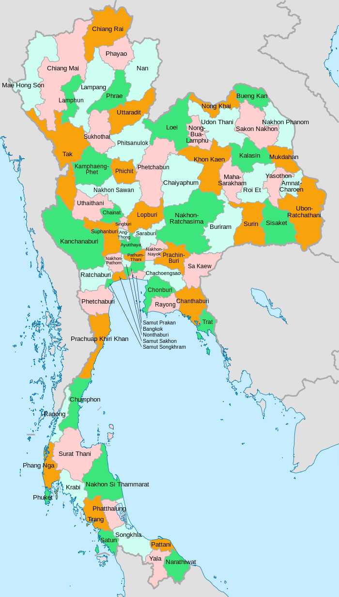
The 76 provinces in Thailand
A clickable map of Thailand exhibiting its provinces
A clickable map of Thailand exhibiting its provinces
Thailand's national government organisation is divided into three types: central government (ministries, bureaus and departments), provincial government (provinces and districts) and local government (Bangkok, Pattaya, provincial administrative organisations, etc.).
A province, as part of the provincial government, is administered by a governor (ผู้ว่าราชการจังหวัด) who is appointed by the Minister of Interior. Bangkok, as part of the local government, is administered by a corporation called Bangkok Metropolitan Administration. The corporation is led by the Governor of Bangkok (ผู้ว่าราชการกรุงเทพมหานคร) who is directly elected by the citizens of Bangkok.
The provinces are named after their original main city, which may not necessarily still be the most populous city within the province today. Also, in several provinces the administration has been moved into a new building outside the city.
History
Before 1892
Many provinces date back to semi-independent local chiefdoms or kingdoms, which made up the Ayutthaya Kingdom. The provinces were created around a capital city (mueang), and included surrounding villages or satellite towns. The provinces were administered either by a governor, who was appointed by the king or by a local ruling family, who were descendants of the old kings and princes of that area and had been given this privilege by the central king. De facto the king did not have much choice but to choose someone from the local nobility or an economically strong man, as against these local power groups the administration would have become impossible. The governor was not paid by the king, but instead financed himself and his administration by imposing local taxes himself. Every province was required to send an annual tribute to Bangkok.
The provinces were divided into four different classes. The first-class were the border provinces. The second-class were those that once had their own princely house. Third-class were provinces that were created by splitting them from other provinces. Fourth-class were provinces near the capital. Additionally tributary states like the principalities of Lan Na, the Laotian kingdoms of Vientiane and Luang Prabang, Cambodia, or the Malay sultanate Kedah were also part of the country, but with more autonomy than the provinces. In this Mandala system the semi-independent countries sometimes were tributary to more than one country.
New provinces were created when the population of an area outgrew the administration, but also for political reasons. If a governor became too dominant in a region former satellite cities were elevated to provincial status, as was the case with Maha Sarakham province.
Reforms of the provincial administration started in the 1870s under increased pressure from the colonial states of the United Kingdom and France. Agents were sent, especially to border areas, to impose more control on the provinces or tributary states.
Administrative reform of 1892
Map of Siam in 1900
At the end of the 19th century King Chulalongkorn reformed the central government. In 1892 the ministry, which previously had many overlapping responsibilities, was reorganized with clear missions as in Western administrations. Prince Damrong Rajanubhab became minister of the Ministry of the North (Mahatthai), originally responsible for the northern administration. When the Ministry of the South (Kalahom) was dissolved in 1894, Prince Damrong became Minister of the Interior, responsible for the provincial administration of the whole country.
Starting in 1893 the already existing commissionaireships in some parts of the country were renamed "superintendent commissioner" (khaluang Thesaphiban), and their area of responsibility was called a monthon. In strategically important areas the monthon were created first, while in other areas the provinces kept their independence a bit longer. Several smaller provinces were reduced in status to an amphoe (district) or even lower to a tambon (sub-district) and included in a neighboring province, sometimes for administrative reasons, but sometimes to remove an uncooperative governor.
In some regions rebellions broke out against the new administrative system, usually induced by the local nobility fearing their loss of power. The most notable was the Holy Man Rebellion in 1902 in Isan. It was initially a messianic doomsday sect, but it also attacked government representatives in the northeast. The provincial town Khemarat was even burned by the rebels. After a few months the rebellion was beaten back.[9]
After 1916, the word changwat became common to use for the provinces, partly to distinguish them from the provincial capital city (mueang or amphoe mueang), but also to stress the new administrative structure of the provinces.[10]
When Prince Damrong resigned in 1915, the whole country was divided into 19 monthon (including the area around Bangkok, which was under the responsibility of another ministry until 1922), with 72 provinces.
In December 1915 King Vajiravudh announced the creation of regions (phak), each administered by a viceroy (upparat), to cover several monthon. Until 1922 four regions were established; however, in 1925 they were dissolved again. At the same time several monthon were merged, in an attempt to streamline administration and reduce costs.
Since 1932
The monthons were dissolved when Thailand transformed from an absolute monarchy into a constitutional monarchy in 1932, making the provinces the top level administrative division again. Several smaller provinces were also abolished at that time. During World War II, several provinces around Bangkok were merged. These changes were undone after the war. Also the occupied area from French Indochina was organized into four provinces: Phra Tabong, Phibunsongkhram, Nakhon Champasak and Lan Chang. The current province of Sukhothai was at first known as Sawankhalok. It was renamed Sukhothai in 1939 (which is why the railway system goes to Sawankhalok city and not Sukhothai city). The province, Kalasin, was reestablished in 1947 after having been dissolved in 1932.
In 1972 Phra Nakhon and Thonburi provinces were merged to form the special administrative area of Bangkok, which combines the tasks of the provinces with that of a municipality, including having an elected governor.
Starting in the second half of the 20th century some provinces were newly created by splitting them off from bigger provinces. In 1975, Yasothon province was split off from Ubon Ratchathani. In 1977, Phayao province was created from districts formerly part of Chiang Rai. In 1982, Mukdahan was split off from Nakhon Phanom. In 1993 three provinces were created: Sa Kaeo (split from Prachinburi), Nong Bua Lamphu province (split from Udon Thani), and Amnat Charoen (split from Ubon Ratchathani). The newest province is Bueng Kan, which was split off from Nong Khai effective 23 March 2011.
Merged into Phra Nakhon province (except Ko Sichang District which was merged into Chonburi province). The part of Phra Nakhon was split out again in 1946
^ abcรายงานสถิติจำนวนประชากรและบ้านประจำปี พ.ศ.2562 [Statistics, population and house statistics for the year 2019]. Registration Office Department of the Interior, Ministry of the Interior. stat.bora.dopa.go.th (in Thai). 31 December 2019. Retrieved 26 February 2020.
^ abc"ตารางที่ 2 พี้นที่ป่าไม้ แยกรายจังหวัด พ.ศ.2562" [Table 2 Forest area Separate province year 2019]. Royal Forest Department (in Thai). 2019. Retrieved 6 April 2021, information, Forest statistics Year 2019, Thailand boundary from Department of Provincial Administration in 2013.
Tej Bunnag (1977). The Provincial Administration of Siam, 1892–1915: the Ministry of the Interior under Prince Damrong Rajanubhab. Kuala Lumpur; New York: Oxford University Press. ISBN0-19-580343-4.
Keluaran 11Gambar sebuah gulungan Taurat modern, terbuka pada halaman yang memuat Kidung Laut (Keluaran 15:1-19) jelas dengan penataan khusus. Teacher's Edition: The Holy Bible. New York: Henry Frowde, Publisher to the University of Oxford, 1896.KitabKitab KeluaranKategoriTauratBagian Alkitab KristenPerjanjian LamaUrutan dalamKitab Kristen2← pasal 10 pasal 12 → Keluaran 11 (disingkat Kel 11) adalah bagian dari Kitab Keluaran dalam Alkitab Ibrani dan Perjanjian Lama di Alkitab Kristen…
John Robinson Información personalNacimiento 29 de diciembre de 1954 (68 años)Creston (Estados Unidos) Nacionalidad EstadounidenseEducaciónEducado en Berklee College of Music Información profesionalOcupación Músico de jazz Años activo desde 1978Género Rock Instrumento Batería Sitio web www.johnjrrobinson.com [editar datos en Wikidata] John Frederick Robinson, conocido profesionalmente como John JR Robinson (nacido el 29 de diciembre de 1954 en Creston, Iowa),[1] es un b…
María Coronada Información personalNombre de nacimiento María Coronada Herrera VicenteNacimiento 11 de septiembre de 1945 (78 años) Badajoz, EspañaBadajoz (España) Nacionalidad EspañolaInformación profesionalOcupación Músico, cantanteSeudónimo María Coronada Instrumento Voz Tipo de voz SopranoDistinciones Primer premio en el Concurso Nacional de Zarzuela de SantanderMedalla de Extremadura[editar datos en Wikidata] María Coronada (Badajoz; 11 de septiembre de 1945) es …
Pulau Natal Pemakaian Bendera sipil dan negara Perbandingan 1:2 Dipakai 14 April 1986 (tidak resmi)26 Januari 2002 (resmi) Rancangan Bicolor diagonal biru dan hijau diisi dengan salib selatan dari empat bintang putih berujung tujuh dan satu bintang putih berujung lima yang lebih kecil di paruh biru, seekor burung bosun emas di emas di bagian hijau, dan lingkaran emas di tengahnya berisi bentuk pulau berwarna hijau Bendera Pulau Natal secara tidak resmi diadopsi pada tahun 1986 setelah terpilih s…
Scottish fiddle band Blazin' Fiddles performing at the Queen's Hall at the Edinburgh Festival 2016 Blazin' Fiddles are a contemporary Scottish fiddle band from the Highlands and Islands. They formed in 1998 to showcase Scotland's distinct regional fiddle styles. The band have a number of awards, including; the MG ALBA Scots Trad Music Awards Live Act of the Year, Album of the Year and Folk Band of the Year. Their records are released on their own indie Blazin' Records label. They have been descr…
Conflict between Carolinian colonial settlers and Native American tribes (1715–17) This article needs additional citations for verification. Please help improve this article by adding citations to reliable sources. Unsourced material may be challenged and removed.Find sources: Yamasee War – news · newspapers · books · scholar · JSTOR (November 2019) (Learn how and when to remove this template message) Yamasee WarPart of the American Indian WarsDateApril…
Hip hop recording artist discography G Herbo discographyG Herbo in 2021Studio albums5EPs2Singles40Mixtapes6 American rapper G Herbo has released five studio albums (including one collaborative album), six mixtapes, two extended plays, and forty singles (including nineteen as a featured artist). Albums Studio albums List of studio albums, with year released Title Album details Peak chart positions Certifications US[1] USR&B/HH[2] USRap[3] CAN[4] Humble Beast Re…
Thomas ByrneVCBornDecember 1866 York St. Dublin, IrelandDied15 March 1944(1944-03-15) (aged 77)Canterbury, EnglandBuriedCanterbury City Cemetery 51°17′09″N 1°03′51″E / 51.285715°N 1.064139°E / 51.285715; 1.064139Allegiance United KingdomService/branch British ArmyYears of service1887 - 1909RankPrivateBattles/wars Mahdist War Second Boer War AwardsVictoria Cross Thomas Byrne, VC (December 1866 Dublin – 15 March 1944) was an Irish Briti…
Speech by US president Bill Clinton 1997 State of the Union AddressFull video of the speech as published by the White HouseDateFebruary 4, 1997 (1997-02-04)Time9:00 p.m. ESTDuration1 hour, 4 minutesVenueHouse Chamber, United States CapitolLocationWashington, D.C.Coordinates38°53′23″N 77°00′32″W / 38.88972°N 77.00889°W / 38.88972; -77.00889TypeState of the Union AddressParticipantsBill ClintonAl GoreNewt Gingrich The 1997 State of the Union …
American actor (1907–1968) Dan DuryeaDuryea as Waco Johnny Dean in Winchester '73 (1950)Born(1907-01-23)January 23, 1907White Plains, New York, U.S.DiedJune 7, 1968(1968-06-07) (aged 61)Los Angeles, California, U.S.Resting placeForest Lawn Memorial Park Cemetery, Hollywood Hills, CaliforniaOccupationActorYears active1933–1968Spouse Helen Bryan (m. 1932; died 1967)Children2, including Peter Duryea Dan Duryea (/ˈdʊri.eɪ/ DUURR-ee…
2010 Chinese census Sixth National Population Census ← 2000 28 April 2011 2020 → General informationCountryChinaResultsTotal population1,339,724,852 ( 7.6%)Most populous provinceGuangdongLeast populous provinceTibet Autonomous Region The 2010 Chinese census, officially the Sixth National Population Census of the People's Republic of China (中华人民共和国第六次全国人口普查), was conducted by the National Bureau of Statistics …
This article may be a rough translation from Spanish. It may have been generated, in whole or in part, by a computer or by a translator without dual proficiency. Please help to enhance the translation. The original article is under español in the languages menu in the upper right corner. See this article's entry on Pages needing translation into English for discussion. (June 2022) List of civil wars in Venezuela The Venezuelan civil wars were a long series of conflicts that devastated the count…
20th Television Тип дочерняя компания Основание 15 мая 1949 Предшественник Touchstone Television (второе воплощение)MTM EnterprisesBlair Entertainment20th Television (первое воплощение)20th Century Fox International Television Прежние названия TCF Television Productions, Inc. (1949–1958)20th Century-Fox Television (1958–1985)20th Century Fox Television (1985–1989; 1994–2020) Расположени…
Family of bivalves Nucinellidae Nucinella dalli[1] Scientific classification Domain: Eukaryota Kingdom: Animalia Phylum: Mollusca Class: Bivalvia Order: Solemyida Superfamily: Manzanelloidea Family: NucinellidaeHE Vokes, 1956 Nucinellidae is a family of bivalves, in the order Solemyida. Its species are small and principally reside in deep-water environments. The species' average length is less than 5 millimetres (0.20 in), the largest species being Nucinella boucheti (La Perna, 2005…
Historic site in Czersk, Masovian Voivodeship; PolandCastle of the Masovian DukesLocationCzersk, Masovian Voivodeship; PolandCoordinates51°57′30″N 21°14′03″E / 51.95833°N 21.23417°E / 51.95833; 21.23417Built1388–1410Demolished1656Rebuilt1762–1766Architectural style(s)GothicLocation of the Czersk Castle in Poland The Castle of the Masovian Dukes is a Gothic castle located in Czersk (36 km south of Warsaw), Masovian Voivodeship in Poland. History The Czersk …
KunamaGeographicdistributionEritrea, EthiopiaLinguistic classificationNilo-Saharan?Maba–Kunama?KunamaSubdivisions Kunama Bitama-Ilit Glottologkuna1268 The Kunama languages are a family of languages traditionally considered dialects of a single language, spoken in western Eritrea and across the border in Ethiopia. They are included as a branch of the Nilo-Saharan language family. The languages are Kunama proper and Ilit. References Blench, Roger. Nilo-Saharan languages list. vteNilo-Saharan lan…
Hebrew codex of the Prophets ascribed to masorete Ben-Asher click on the picture to see all pages of Codex Cairensis (a PDF file) The Codex Cairensis (also: Codex Prophetarum Cairensis, Cairo Codex of the Prophets) is a Hebrew manuscript containing the complete text of the Hebrew Bible's Nevi'im (Prophets). It has traditionally been described as the oldest dated Hebrew Codex of the Bible which has come down to us,[1] but modern research seems to indicate an 11th-century date rather than …
Volcanic island in Visayas, Philippines Not to be confused with Apo Island part of Apo Reef, west of Occidental Mindoro. Barangay in Visayas, PhilippinesApo IslandBarangayView of Apo Island from the westMap of Negros Oriental showing the location of Apo Island.Coordinates: 9°4′N 123°16′E / 9.067°N 123.267°E / 9.067; 123.267CountryPhilippinesIsland groupVisayasRegionCentral VisayasProvinceNegros OrientalMunicipalityDauinArea • Total0.74 km2 (0.29&#…
O Circuito Brasileiro de Voleibol de Praia Feminino de 2011, também chamado de Circuito Banco do Brasil de Vôlei de Praia, foi a vigésima primeira edição da principal competição nacional de Vôlei de Praia na variante masculina, realizado de 12 de janeiro a 11 de dezembro, dividido em doze etapas, sediados em doze Estados diferentes.[1] Resultados Evento Ouro Prata Bronze Quarto lugar 1ª EtapaVitória, Espírito Santo12 a 16 de janeiro de 2011[1][2] /Ricardo Alex SantosMárcio Araújo /E…


")
")


")


