| Станція |
Фото |
Відкриття |
Додаткова інформація |
Розташування
|
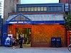
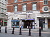
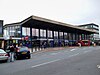
| Гаммерсміт |
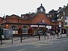 |
13 червня 1864 |
Відкриття на сьогоденному місці 1 грудня 1868 року. |
51°29′39″ пн. ш. 000°13′30″ зх. д. / 51.49417° пн. ш. 0.22500° зх. д. / 51.49417; -0.22500 (01 - Hammersmith tube station)
|
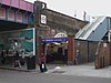
| Голдгок-роуд |
 |
1 квітня 1914 |
|
51°30′07″ пн. ш. 000°13′37″ зх. д. / 51.50194° пн. ш. 0.22694° зх. д. / 51.50194; -0.22694 (02 - Goldhawk Road tube station)
|
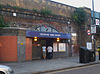
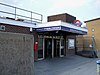
| Шепгердс-Буш-маркет |
 |
13 червня 1864 |
Відкриття на сьогоденному місці 1 квітня 1914. Перейменовано з "Шеффердс-Буш" у 2008.[7] |
51°30′21″ пн. ш. 000°13′35″ зх. д. / 51.50583° пн. ш. 0.22639° зх. д. / 51.50583; -0.22639 (03 - Shepherd's Bush Market tube station)
|
| Вуд-лейн |
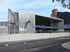 |
12 жовтня 2008 |
[8] |
51°30′35″ пн. ш. 000°13′27″ зх. д. / 51.50972° пн. ш. 0.22417° зх. д. / 51.50972; -0.22417 (04 - Wood Lane tube station)
|
| Летімер-роуд |
 |
16 грудня 1868 |
Зачинена 17 січня — 1 серпня 2011 на реконструкцію[9] |
51°30′50″ пн. ш. 000°13′02″ зх. д. / 51.51389° пн. ш. 0.21722° зх. д. / 51.51389; -0.21722 (05 - Latimer Road tube station)
|
| Ледброк-гроув |
 |
13 червня 1864 |
Відкрито як Ноттінг-гілл, перейменовано на Ноттінг-гілл-енд-Ледброк-гроув у 1880, Ледброк-гроув (Норт-Кенсінгтон) у 1919 та Ледброк-гроув у 1938. |
51°31′02″ пн. ш. 000°12′38″ зх. д. / 51.51722° пн. ш. 0.21056° зх. д. / 51.51722; -0.21056 (06 - Ladbroke Grove tube station)
|
| Вестборн-парк |
 |
1 лютого 1866 |
Відкриття на сьогоденному місці 1 листопада 1871,, станція Great Western main-line до 1992.[10] |
51°31′16″ пн. ш. 000°12′04″ зх. д. / 51.52111° пн. ш. 0.20111° зх. д. / 51.52111; -0.20111 (07 - Westbourne Park tube station)
|
| Роял-Оук |
 |
30 жовтня 1871 |
Як станція Great Western main-line до 1934. |
51°31′09″ пн. ш. 000°11′17″ зх. д. / 51.51917° пн. ш. 0.18806° зх. д. / 51.51917; -0.18806 (08 - Royal Oak tube station)
|
| Паддінгтон |
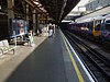 |
10 січня 1863 |
Відкрита як Паддінгтон (Бішопс-роуд), перейменована в 1948.
Пересадки на лінії Бейкерлоо, Кільцева та Дистрикт та залізничну станцію Паддінгтон |
51°31′07″ пн. ш. 000°10′46″ зх. д. / 51.51861° пн. ш. 0.17944° зх. д. / 51.51861; -0.17944 (09 - Paddington station (H&C platforms))
|
| Еджвар-роуд |
 |
10 січня 1863 |
Пересадка на потяги ліній Кільцева, Дистрикт |
51°31′12″ пн. ш. 000°10′04″ зх. д. / 51.52000° пн. ш. 0.16778° зх. д. / 51.52000; -0.16778 (10 - Edgware Road tube station)
|
| Бейкер-стріт |
 |
10 січня 1863 |
Пересадка на потяги ліній Бейкерлоо, Джубилі та Метрополітен. |
51°31′19″ пн. ш. 000°09′25″ зх. д. / 51.52194° пн. ш. 0.15694° зх. д. / 51.52194; -0.15694 (11 - Baker Street tube station)
|
| Грейт-Портленд-стріт |
 |
10 січня 1863 |
Відкрита як «Портленд-роуд», перейменована на «Грейт-Портленд-стріт» у 1917. Мала назву «Грейт-Портленд-стріт-енд-Риджентс-парк» в 1923–33. |
51°31′26″ пн. ш. 000°08′38″ зх. д. / 51.52389° пн. ш. 0.14389° зх. д. / 51.52389; -0.14389 (12 - Great Portland Street tube station)
|
| Юстон-сквер |
 |
10 січня 1863 |
Відкрита як «Гавер-стріт» та перейменована в 1909. Пересадки на залізничну станцію Юстон. |
51°31′33″ пн. ш. 000°08′09″ зх. д. / 51.52583° пн. ш. 0.13583° зх. д. / 51.52583; -0.13583 (13 - Euston Square tube station)
|
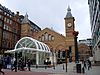
| Кінгс-кросс-Сент-Панкрас |
 |
10 січня 1863 |
Відкрита як «Кінгс-кросс», перейменована на «Кінгс-кросс-енд-Сент-Панкрас» в 1925 та «Кінгс-кросс-Сент-Панкрас» в 1933. Відкрито на цьому місці in 1941
Пересадки на Північну, Пікаділлі, Вікторія та на залізничні станції Сент-Панкрас, Кінгс-кросс |
51°31′49″ пн. ш. 000°07′27″ зх. д. / 51.53028° пн. ш. 0.12417° зх. д. / 51.53028; -0.12417 (14 - King's Cross St. Pancras tube station)
|
| Фаррінгдон |
 |
10 січня 1863 |
Відкрита як «Фаррінгдон-стріт». Відкрито на цьому місці у 1865. Перейменовано на «Фаррінгдон-енд-Хай-Голборн» в 1922 та Фаррінгдон в 1936.
Пересадка на потяги Thameslink. |
51°31′12″ пн. ш. 000°06′19″ зх. д. / 51.52000° пн. ш. 0.10528° зх. д. / 51.52000; -0.10528 (15 - Farringdon station)
|
| Барбікан |
 |
23 грудня 1865 |
Відкрита як «Олдерсгейт-стріт», у 1910 перейменовано на «Олдерсгейт», в 1923 — на «Олдерсгейт-енд-Барбікан», в 1968 — на «Барбікан». |
51°31′13″ пн. ш. 000°05′52″ зх. д. / 51.52028° пн. ш. 0.09778° зх. д. / 51.52028; -0.09778 (16 - Barbican tube station)
|
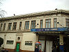
| Моргейт |
 |
23 грудня 1865 |
відкрита як «Моргейт-стріт», сьогоденна назва з 1924.
Пересадка на Північну лінію та приміську Northern City Line |
51°31′07″ пн. ш. 000°05′19″ зх. д. / 51.51861° пн. ш. 0.08861° зх. д. / 51.51861; -0.08861 (17 - Moorgate station)
|
| Ліверпуль-стріт |
 |
11липня 1875 |
Лютий — липень 1875 використовувалась як залізнична.
Пересадка на потяги ліній Центральна, Кільцева та залізничну станцію «Ліверпуль-стріт» |
51°31′04″ пн. ш. 000°04′59″ зх. д. / 51.51778° пн. ш. 0.08306° зх. д. / 51.51778; -0.08306 (18 - Liverpool Street station)
|
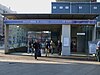
| Олдгейт-Іст |
 |
6 жовтня 1884 |
Пересадка на лінію Дистрикт. На сьогоденному місці з 1938. |
51°30′55″ пн. ш. 000°04′20″ зх. д. / 51.51528° пн. ш. 0.07222° зх. д. / 51.51528; -0.07222 (19 - Aldgate East tube station)
|
| Вайтчепел |
 |
6 жовтня 1884 |
Пересадка на потяги London Overground. Відкрито як «Вайтчепл (Майл-Енд)», перейменовано у 1901.. |
51°31′08″ пн. ш. 000°03′40″ зх. д. / 51.51889° пн. ш. 0.06111° зх. д. / 51.51889; -0.06111 (20 - Whitechapel station)
|
| Степні-Грін |
 |
23 червня 1902 |
Обслуговує лінію Metropolitan з 1941. |
51°31′19″ пн. ш. 000°02′47″ зх. д. / 51.52194° пн. ш. 0.04639° зх. д. / 51.52194; -0.04639 (21 - Stepney Green tube station)
|
| Майл-Енд |
 |
2 червня 1902 |
кросплатформова пересадка на Центральну лінію. |
51°31′30″ пн. ш. 000°01′59″ зх. д. / 51.52500° пн. ш. 0.03306° зх. д. / 51.52500; -0.03306 (22 - Mile End tube station)
|
| Боу-роуд |
 |
11 червня 1902 |
Залізнична станція відкрита в 1876 на сьогоденному місці з 1892. Обслуговує лінію Metropolitan з 1936, Залізнична станція зачинена в 1947. |
51°31′38″ пн. ш. 000°01′29″ зх. д. / 51.52722° пн. ш. 0.02472° зх. д. / 51.52722; -0.02472 (23 - Bow Road tube station)
|
| Бромлі-бай-Боу |
 |
2 червня 1902 |
Відкрита у складі LT&SR у 1894, під назвою «Бромлі», трафік на LT&SR закрито в 1940 і перейменовано в 1967. |
51°31′26″ пн. ш. 000°00′41″ зх. д. / 51.52389° пн. ш. 0.01139° зх. д. / 51.52389; -0.01139 (24 - Bromley-by-Bow tube station)
|
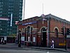
| Вест-Гем |
 |
2 червня 1902 |
Пересадка на лінії Джубилі DLR, та National Rail. Мала назву Вест-Гам (Менор-роад) у 1924 — 1969, обслуговувала лінію Метрополітен з 1941, припинення трафіку Метрополітен та LT&SR з 1994 |
51°31′41″ пн. ш. 000°00′14″ сх. д. / 51.52806° пн. ш. 0.00389° сх. д. / 51.52806; 0.00389 (25 - West Ham station)
|
| Плейстоу |
 |
2 червня 1902 |
Станція LT&SR з 1858 Metropolitan service began in 1936. |
51°31′53″ пн. ш. 000°01′02″ сх. д. / 51.53139° пн. ш. 0.01722° сх. д. / 51.53139; 0.01722 (26 - Plaistow tube station)
|
| Аптон-парк |
 |
2 червня 1902 |
Станція LT&SR з 1877. Обслуговує лінію Metropolitan з 1936. |
51°32′06″ пн. ш. 000°02′04″ сх. д. / 51.53500° пн. ш. 0.03444° сх. д. / 51.53500; 0.03444 (27 - Upton Park tube station)
|
| Іст-Гем |
 |
2 червня 1902 |
Залізнична станція відкрита в 1858. Обслуговує лінію Metropolitan з 1936. |
51°32′20″ пн. ш. 000°03′06″ сх. д. / 51.53889° пн. ш. 0.05167° сх. д. / 51.53889; 0.05167 (28 - East Ham tube station)
|
| Баркінг |
 |
2 червня 1902 |
Пересадка на потяги National Rail та London Overground. Станція LT&SR відкрита у 1854. Припинення трафіку District Railway 1905–1908. Обслуговує лінію Metropolitan з 1936. |
51°32′21″ пн. ш. 000°04′54″ сх. д. / 51.53917° пн. ш. 0.08167° сх. д. / 51.53917; 0.08167 (29 - Barking station)
|

_station_building.JPG)


