Mōkau
Mōkau is a small town in the Waitomo District, North Island and is just north of the Taranaki Region. It is located 90 northwest of New Plymouth and State High
Mōkau | |
|---|---|
Village | |
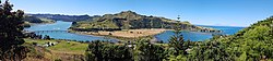
 Mōkau panorama: river, SH3 bridge, beach - and Mt. Taranaki far away (82km = 51mi) in the background | |
 | |
| Coordinates: 38°41′S 174°37′E / 38.683°S 174.617°E | |
| Country | New Zealand |
| Region | Waikato region |
| District | Waitomo District |
| Ward | Waitomo Rural Ward |
| Electorates | |
| Government | |
| • Territorial Authority | Waitomo District Council |
| • Regional council | Waikato Regional Council |
| Area | |
| • Territorial | 19.82 km2 (7.65 sq mi) |
| Population (June 2023)[2] | |
| • Territorial | 100 |
| • Density | 5.0/km2 (13/sq mi) |
| Time zone | UTC+12 (NZST) |
| • Summer (DST) | UTC+13 (NZDT) |
Mōkau is a small town in the Waitomo District, North Island and is just north of the Taranaki Region. It is located 90 northwest of New Plymouth and State Highway 3 is the gateway from Te Kuiti and Waitara. It has a primary school in the township.
References
- ↑ "ArcGIS Web Application". statsnz.maps.arcgis.com. Archived from the original on 24 March 2023. Retrieved 4 May 2024.
- ↑ "Subnational population estimates (RC, SA2), by age and sex, at 30 June 1996-2023 (2023 boundaries)". Statistics New Zealand. Retrieved 25 October 2023. (regional councils); "Subnational population estimates (TA, SA2), by age and sex, at 30 June 1996-2023 (2023 boundaries)". Statistics New Zealand. Retrieved 25 October 2023. (territorial authorities); "Subnational population estimates (urban rural), by age and sex, at 30 June 1996-2023 (2023 boundaries)". Statistics New Zealand. Retrieved 25 October 2023. (urban areas)
 This short article about a place or feature can be made longer. You can help Wikipedia by adding to it.
Content Disclaimer
Informasi ini disarikan dari Wikipedia dan disajikan kembali untuk tujuan edukasi. Konten tersedia di bawah lisensi CC BY-SA 3.0. Kami tidak bertanggung jawab atas ketidakakuratan data yang bersumber dari kontribusi publik tersebut.
- The information displayed on this website is sourced in part or in whole from Wikipedia and has been adapted for the purpose of restating it. We strive to provide accurate and relevant information, however:
- There is no guarantee of absolute accuracy. Wikipedia is an open, collaborative project that can be edited by anyone, so information is subject to change.
- It is not intended to constitute professional advice. The content displayed is for informational and educational purposes only. For important decisions (e.g., medical, legal, or financial), please consult a professional.
- Content copyright. Wikipedia is licensed under the Creative Commons Attribution-ShareAlike License (CC BY-SA). This means that content may be reused with appropriate attribution and shared under a similar license.
- Responsible use. Any risk arising from the use of information from this website is entirely the responsibility of the user.