Lorscheid
Lorscheid is a village and a part of the Ruwer (municipality) near Trier in Rhineland-Palatinate, Germany.
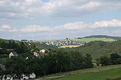
Lorscheid | |
|---|---|
 | |
 Coat of arms | |
Location of Lorscheid within Trier-Saarburg district  | |
  Lorscheid  Lorscheid | |
| Coordinates: 49°44′14″N 6°50′57″E / 49.73722°N 6.84917°E | |
| Country | Germany |
| State | Rhineland-Palatinate |
| District | Trier-Saarburg |
| Municipal assoc. | Ruwer |
| Government | |
| • Mayor | Jutta Gard-Becker |
| Area | |
| • Total | 5.09 km2 (1.97 sq mi) |
| Elevation | 420 m (1,380 ft) |
| Population (2023-12-31)[1] | |
| • Total | 539 |
| • Density | 110/km2 (270/sq mi) |
| Time zone | UTC+01:00 (CET) |
| • Summer (DST) | UTC+02:00 (CEST) |
| Postal codes | 54317 |
| Dialling codes | 06500 |
| Vehicle registration | TR |
Lorscheid is a village and a part of the Ruwer (municipality) near Trier in Rhineland-Palatinate, Germany.
Lorscheid is on an old Roman road. Many archaeological settlements are nearby. The village is first mentioned in the inventory of the Abbey of St. Maximin in Trier for the year 1211.
References
- ↑ Bevölkerungsstand 31. Dezember 2023, Landkreise, Gemeinden, Verbandsgemeinden; Fortschreibung des Zensus 2011 (in German), Statistisches Landesamt Rheinland-Pfalz, 2024
Other websites
 Media related to Lorscheid at Wikimedia Commons

| International | |
|---|---|
| National | |

 This short article about a place or feature can be made longer. You can help Wikipedia by adding to it.
Content Disclaimer
Informasi ini disarikan dari Wikipedia dan disajikan kembali untuk tujuan edukasi. Konten tersedia di bawah lisensi CC BY-SA 3.0. Kami tidak bertanggung jawab atas ketidakakuratan data yang bersumber dari kontribusi publik tersebut.
- The information displayed on this website is sourced in part or in whole from Wikipedia and has been adapted for the purpose of restating it. We strive to provide accurate and relevant information, however:
- There is no guarantee of absolute accuracy. Wikipedia is an open, collaborative project that can be edited by anyone, so information is subject to change.
- It is not intended to constitute professional advice. The content displayed is for informational and educational purposes only. For important decisions (e.g., medical, legal, or financial), please consult a professional.
- Content copyright. Wikipedia is licensed under the Creative Commons Attribution-ShareAlike License (CC BY-SA). This means that content may be reused with appropriate attribution and shared under a similar license.
- Responsible use. Any risk arising from the use of information from this website is entirely the responsibility of the user.