Kalchreuth
Kalchreuth is a municipality in the district of Erlangen-Höchstadt, in Bavaria, Germany. It is 10 kilometers east of Erlangen and 15 kilometers north of Nuremb…
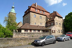
Kalchreuth | |
|---|---|
 Kalchreuth Castle | |
 Coat of arms | |
Location of Kalchreuth within Erlangen-Höchstadt district  | |
  Kalchreuth  Kalchreuth | |
| Coordinates: 49°34′N 11°08′E / 49.567°N 11.133°E | |
| Country | Germany |
| State | Bavaria |
| Admin. region | Mittelfranken |
| District | Erlangen-Höchstadt |
| Government | |
| • Mayor (2020–26) | Herbert Saft[1] (FW) |
| Area | |
| • Total | 10.84 km2 (4.19 sq mi) |
| Elevation | 413 m (1,355 ft) |
| Population (2024-12-31)[2] | |
| • Total | 2,994 |
| • Density | 280/km2 (720/sq mi) |
| Time zone | UTC+01:00 (CET) |
| • Summer (DST) | UTC+02:00 (CEST) |
| Postal codes | 90562 |
| Dialling codes | 0911 |
| Vehicle registration | ERH |
| Website | www.kalchreuth.de |
Kalchreuth is a municipality in the district of Erlangen-Höchstadt, in Bavaria, Germany. It is 10 kilometers east of Erlangen and 15 kilometers north of Nuremberg and contains the villages of Kalchreuth, Käswasser and Röckenhof and also the hamlets of Stettenberg, Minderleinsmühle and Gabermühle.
Twin towns
 La Chapelle-des-Fougeretz (France), since 1993

References
- ↑ Liste der ersten Bürgermeister/Oberbürgermeister in kreisangehörigen Gemeinden, Bayerisches Landesamt für Statistik, 15 July 2021.
- ↑ "Gemeinden, Kreise und Regierungsbezirke in Bayern, Einwohnerzahlen am 31. Dezember 2024; Basis Zensus 2022" [Municipalities, counties, and administrative districts in Bavaria; Based on the 2022 Census] (CSV) (in German). Bayerisches Landesamt für Statistik.
Places next to Kalchreuth | |
|---|---|


Towns and municipalities in Erlangen-Höchstadt | ||
|---|---|---|
 | ||
| International | |
|---|---|
| National | |
| Geographic | |

Content Disclaimer
Informasi ini disarikan dari Wikipedia dan disajikan kembali untuk tujuan edukasi. Konten tersedia di bawah lisensi CC BY-SA 3.0. Kami tidak bertanggung jawab atas ketidakakuratan data yang bersumber dari kontribusi publik tersebut.
- The information displayed on this website is sourced in part or in whole from Wikipedia and has been adapted for the purpose of restating it. We strive to provide accurate and relevant information, however:
- There is no guarantee of absolute accuracy. Wikipedia is an open, collaborative project that can be edited by anyone, so information is subject to change.
- It is not intended to constitute professional advice. The content displayed is for informational and educational purposes only. For important decisions (e.g., medical, legal, or financial), please consult a professional.
- Content copyright. Wikipedia is licensed under the Creative Commons Attribution-ShareAlike License (CC BY-SA). This means that content may be reused with appropriate attribution and shared under a similar license.
- Responsible use. Any risk arising from the use of information from this website is entirely the responsibility of the user.