Custer County, Idaho

Custer County
Mill used to process gold and silver ore at Yankee Fork mining operations.
Map of Idaho highlighting Custer County
Location within the U.S. state of Idaho
Map of the United States highlighting Idaho
Idaho's location within the U.S.
Coordinates: 44°14′N 114°17′W / 44.23°N 114.29°W / 44.23; -114.29
Country United States
State Idaho
FoundedJanuary 8, 1881
Named forGeneral Custer gold mine
SeatChallis
Largest cityChallis
Area
 • Total4,937 sq mi (12,790 km2)
 • Land4,921 sq mi (12,750 km2)
 • Water16 sq mi (40 km2)  0.3%
Population
 (2020)
 • Total4,249
 • Density0.88/sq mi (0.34/km2)
Time zoneUTC−7 (Mountain)
 • Summer (DST)UTC−6 (MDT)
Congressional district2nd
Websitewww.co.custer.id.us
Leatherman Peak, 12,228 feet (3,727 m), second highest in Idaho, in the Lost River Range in eastern Custer County

Custer County is a county in U.S. state of Idaho. In the 2020 census, the population was 4,249.[1] The county seat is Challis.[2]

Communities
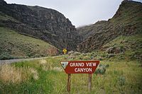
Grand View Canyon (US-93)between Mackay and Challis
Grand View Canyon (US-93)

Cities

Unincorporated communities

Ghost towns

References

  1. "QuickFacts: Custer County, Idaho". United States Census Bureau. Retrieved September 25, 2023.
  2. "Find a County". National Association of Counties. Retrieved 2011-06-07.

Other websites

44°14′N 114°17′W / 44.23°N 114.29°W / 44.23; -114.29


Strategi Solo vs Squad di Free Fire: Cara Menang Mudah!