WSR-57 radars were the primary weather surveillance radar used by the United States for over 35 years.[1] The National Weather Service operated a network of this model radar across the country, watching for severe weather.
The WSR-57 (Weather Surveillance Radar - 1957) was the first 'modern' weather radar. Initially commissioned at the Miami Hurricane Forecast Center, the WSR-57 was installed in other parts of the Contiguous United States (CONUS).[2] The WSR-57 was the first generation of radars designed expressly for a national warning network.[3]
The WSR-57 was designed in 1957 by Dewey Soltow using World War II technology, using modified versions of those used by United States Navy aircraft. Designated AN/FPS-41 by the military, it provided only coarse reflectivity data and no velocity data, which made it extremely difficult to predict tornadoes.[2] Weather systems were traced across the radar screen using grease pencils. Forecasters had to manually turn a crank to adjust the radar's scan elevation, and needed considerable skill to judge the intensity of storms based on green blotches on the radar scope.[1]
As the network of WSR-57 radars aged, some were replaced with WSR-74S models of similar performance but with better reliability. WSR-57 operators sometimes had to scramble for spare parts no longer manufactured in this country.[1] 128 of the WSR-57 and WSR-74 model radars were spread across the country as the National Weather Service's radar network until the 1990s.[5] The WSR-57 radars were gradually replaced by the Weather Surveillance Radar - 1988, Doppler, WSR-88D, which NOAA named the NEXRAD network. The last WSR-57 radar in the United States was decommissioned on December 2, 1996.[1]
Radar properties
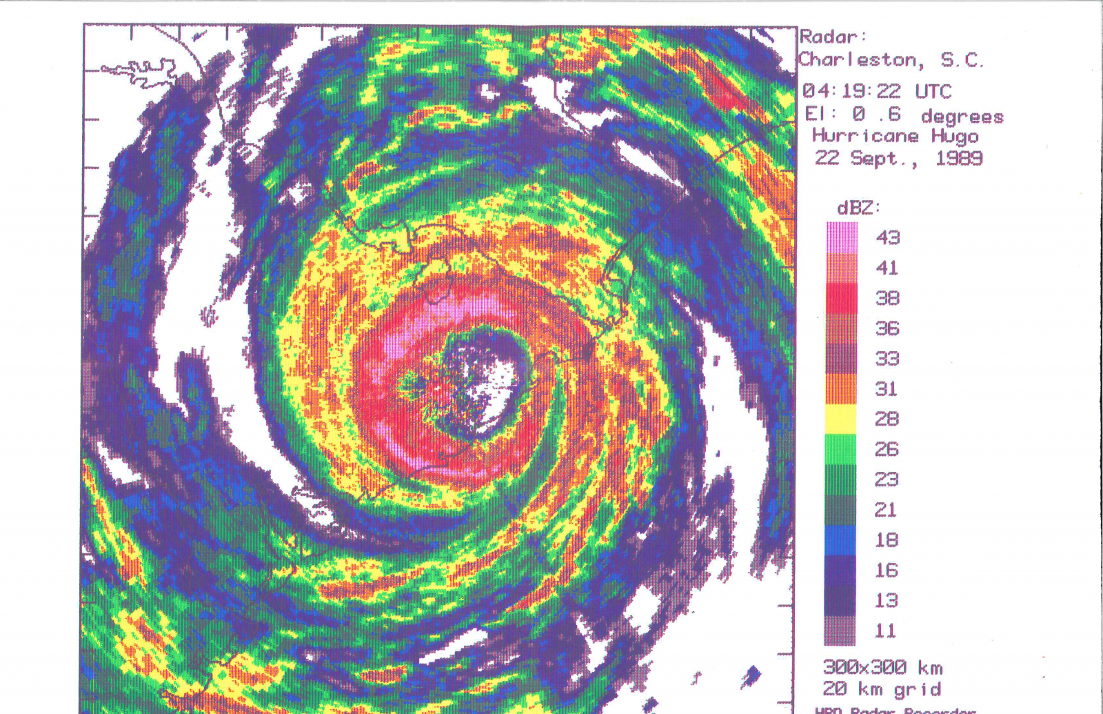
Last image of Miami's WSR-57 blown off by Hurricane Andrew.
Operates on a wavelength of 10.3 cm (2,900 MHz),[6] in the S band, which is also used by today's weather radar network.
Under the Joint Electronics Type Designation System (JETDS), all U.S. military radar and tracking systems are assigned a unique identifying alphanumeric designation. The letters “AN” (for Army-Navy) are placed ahead of a three-letter code.[7]
The first letter of the three-letter code denotes the type of platform hosting the electronic device, where A=Aircraft, F=Fixed (land-based), S=Ship-mounted, and T=Ground transportable.
The second letter indicates the type of equipment, where P=Radar (pulsed), Q=Sonar, and R=Radio.
The third letter indicates the function or purpose of the device, where G=Fire control, R=Receiving, S=Search, and T=Transmitting.
Thus, the AN/FPS-41 represents the 41st design of an Army-Navy “Fixed, Radar, Search” electronic device.[7][8]
Radar sites
The 66[1] former sites of the WSR-57 include[2][9][10][11] the following:
Research radar; not part of the national operational network. Originally located at NSSL facility on the University of Oklahoma - Norman's North Research Campus near 35.23807,-97.46264 and later relocated to Woodward, OK in the 1980s as an off-network radar operated to support local emergency management and ARES services in an area of poor network radar coverage. Radar tower and antenna remains in place at 36.44133,-99.37137
1962?
Probably not counted among first 31
1980s
Catalina Island, CA (STC?)
a.k.a. Santa Catalina - atop Blackjack Mountain.
June 1, 1963
Among first 31
March 24, 1968
Station closed
Little Rock, AR (LIT was the WSR-57 designator. LZK is the WSR-88D and WFO Designation.)
April 19, 1961
Among first 31
Moved to North Little Rock Airport with NWSFO in 1975. Final decommissioning was June 8, 1995
Sacramento, CA (SAC)
February 2, 1960
Among first 31
August 24, 1995
Washington, D.C. (IAD)
At Washington Dulles International Airport, Dulles, VA.
At Jackson International Airport at Thompson Field.
March 7, 1969
Replaced a WSR-3
June 21, 1995
Limon, CO (LIC)
July 1, 1970
December 22, 1995
Garden City, KS (GCK)
March 31, 1970
September 1, 1994
Grand Island, NE (GRI)
June 15, 1971
January 19, 1996
Has been torn down to make way for a new airport terminal
Buffalo, NY (BUF)
October 29, 1961
February 14, 1996
A note on the chronological ranks - The first 31 were built through the early 1960s, at existing Weather Bureau offices. 14 were along the Gulf and Atlantic coasts. 11 were in the Midwest. 3 were inland of the East Coast, and California and Montana had one each on mountaintops. The late 1960s saw 14 more built east of the Rockies.
^National Weather Service Detroit/Pontiac Forecast Office. "Beecher 50th Anniversary Commemoration". National Weather Service Central Region Headquarters. Retrieved 2014-06-26.


