Talk:Triangle (Israel)
.ECR-edit-request-warning {
	display: none;
}
Stop: You may only use this page to create an edit requestThis article is related to the Arab–Israeli conflict,


 | You are an administrator, so you may disregard the message below You are seeing this because of the limitations of {{If extended confirmed}} and {{If admin}}
You can hide this message box by adding the following to a new line of your common.css page: .ECR-edit-request-warning {
display: none;
}
Stop: You may only use this page to create an edit request This article is related to the Arab–Israeli conflict, which is subject to the extended-confirmed restriction. You are not an extended-confirmed user, so you must not edit or discuss this topic anywhere on Wikipedia except to make an edit request. (Additional details are in the message box just below this one.) |
| Warning: active arbitration remedies The contentious topics procedure applies to this article. This article relates to the Arab–Israeli conflict.The following restrictions apply to everyone editing this article:
Editors who repeatedly or seriously fail to adhere to the purpose of Wikipedia, any expected standards of behaviour, or any normal editorial process may be blocked or restricted by an administrator. |
Map
A map would greatly enhance this article. --93.196.46.70 (talk) 20:46, 2 September 2008 (UTC)
Little triangle
During the 1948 Arab–Israeli War, there was another area called 'little triangle', namely the Arab enclave on the Tel Aviv–Haifa road that held out until the first ceasefire. The villages were Jaba'a, Ijzim and Ayn Ghazal. I have a semi-reliable source for this which I'm reluctant to add. Does anyone know what I'm talking about and/or have a source? -- Ynhockey (Talk) 02:57, 31 December 2008 (UTC)
strange claim
"to differentiate it from the larger "Triangle" region between Jenin, Tulkarm, and Nablus, so-called due to the extensive anti-Jewish attacks there during the 1936–1939 Arab revolt"
---How does that make any sense? Why would the name "triangle" result from such attacks? Zerotalk 11:54, 15 July 2009 (UTC)
Map

@Bolter21: do you have any idea why this is called "The Triangle"? I have added a map, and it doesn't look very triangular to me... Is there a name for the cluster of Arab localities in the Northern District? That is a much bigger cluster, and is also much more triangular. Onceinawhile (talk) 12:23, 21 July 2020 (UTC)
- There was the "small triangle" (Ijzm, Ayn Ghazel and Jaba') on the coast, and the "large triangle" referred to the area between Nablus, Jenin, and Tulkarm. The Arab settlements transferred from Jordan to Israel were roughly in that region and so the Arab settlements in central Israel and the Wadi Ara region are referred by that name. Jenin-Tulkarm-Nablus are no longer referred to as the "triangle" anymore. For some unknown reason and with no sources, the Triangle (Israel) says that the "little triangle" is near Kafr Qassem, which is not true to my knowledge.--Bolter21 (talk to me) 12:48, 21 July 2020 (UTC)
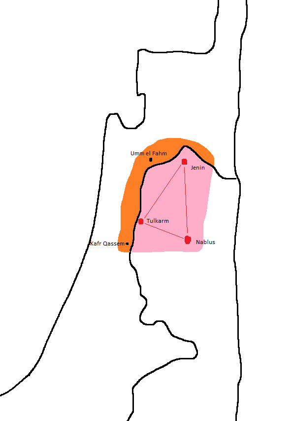
- @Bolter21: when you say "The Arab settlements transferred from Jordan to Israel were roughly in that region" do you mean the red area in this map to the right? I still can't see a triangle there. The Jerusalem Post even call it the "Galilee Triangle"[1], which is a much better description for the red triangle at the top of this map... Onceinawhile (talk) 12:59, 21 July 2020 (UTC)
- The original triangle was the Arab villages of northern Samaria, between Nablus, Jenin and Tulkarm. The term was used by the Hagannah to refer to a large cluster of Arab settlements where the ALA and later Iraqi troops were stationed. The Arab settlements between the area of Kafr Qassem to Umm el Fahm are roughly in that region. They are called the "triangle" while they are really only the western edge of the original triangle. Please appreciate my mad ms.paint skills. I'll maybe make a better map for the article, but I am gonna have to look at sources to back it up so it won't be pure WP:OR. And "Galilee Triangle" is a pretty bad term. It is not used for the two Arab villages in the Jezreel Valley annexed to Israel in 1949 (Muqeible and Sandala, Israel). The connection between the Triangle to the Galilee is a result of geographical ignorance.--Bolter21 (talk to me) 13:13, 21 July 2020 (UTC)
- Hi Bolter21, that is a very good diagram – clears it up for the first time. Impressive paint skills if you ask me. Onceinawhile (talk) 13:38, 21 July 2020 (UTC)
- The original triangle was the Arab villages of northern Samaria, between Nablus, Jenin and Tulkarm. The term was used by the Hagannah to refer to a large cluster of Arab settlements where the ALA and later Iraqi troops were stationed. The Arab settlements between the area of Kafr Qassem to Umm el Fahm are roughly in that region. They are called the "triangle" while they are really only the western edge of the original triangle. Please appreciate my mad ms.paint skills. I'll maybe make a better map for the article, but I am gonna have to look at sources to back it up so it won't be pure WP:OR. And "Galilee Triangle" is a pretty bad term. It is not used for the two Arab villages in the Jezreel Valley annexed to Israel in 1949 (Muqeible and Sandala, Israel). The connection between the Triangle to the Galilee is a result of geographical ignorance.--Bolter21 (talk to me) 13:13, 21 July 2020 (UTC)
- @Bolter21: when you say "The Arab settlements transferred from Jordan to Israel were roughly in that region" do you mean the red area in this map to the right? I still can't see a triangle there. The Jerusalem Post even call it the "Galilee Triangle"[1], which is a much better description for the red triangle at the top of this map... Onceinawhile (talk) 12:59, 21 July 2020 (UTC)
Edit request 13 February 2025
 | This edit request has been answered. Set the |answered= parameter to no to reactivate your request. |
Description of suggested change: Grammar and clarity Diff:
| − | + | The settlements forming the original "Arab Triangle" of Mandatory Palestine (now Palestinian enclaves in the West Bank), are marked in white |
PotatoKugel (talk) 15:04, 13 February 2025 (UTC)
 Done Thank you for the suggestion. P1221 (talk) 12:22, 14 February 2025 (UTC)
- Perhaps for consistency, can you change "Major localities in the Triangle or "Little Triangle", marked in green." to Major localities in the Triangle or "Little Triangle" are marked in green" (to make it consistent with the second sentence which says "are marked in white". PotatoKugel (talk) 04:31, 19 February 2025 (UTC)

Extended-confirmed-protected edit request on 25 July 2025
| This edit request has been answered. Set the |answered= parameter to no to reactivate your request. |
I think the town Jatt should be added to this article as it is not mentioned.
Jatt: https://en.wikipedia.org/wiki/Jatt,_Israel Abo Wisam (talk) 00:19, 25 July 2025 (UTC)
 Not done: it's not clear what changes you want to be made. Please mention the specific changes in a "change X to Y" format and provide a reliable source if appropriate. Please note that you cannot cite another Wikipedia article as a source. You must provide an external reliable source. SI09 (talk) 00:54, 25 July 2025 (UTC)

Content Disclaimer
Informasi ini disarikan dari Wikipedia dan disajikan kembali untuk tujuan edukasi. Konten tersedia di bawah lisensi CC BY-SA 3.0. Kami tidak bertanggung jawab atas ketidakakuratan data yang bersumber dari kontribusi publik tersebut.
- The information displayed on this website is sourced in part or in whole from Wikipedia and has been adapted for the purpose of restating it. We strive to provide accurate and relevant information, however:
- There is no guarantee of absolute accuracy. Wikipedia is an open, collaborative project that can be edited by anyone, so information is subject to change.
- It is not intended to constitute professional advice. The content displayed is for informational and educational purposes only. For important decisions (e.g., medical, legal, or financial), please consult a professional.
- Content copyright. Wikipedia is licensed under the Creative Commons Attribution-ShareAlike License (CC BY-SA). This means that content may be reused with appropriate attribution and shared under a similar license.
- Responsible use. Any risk arising from the use of information from this website is entirely the responsibility of the user.