According to the Köppen climate classification system, Snowdon Peak is located in an alpine subarctic climate zone with long, cold, snowy winters, and cool to warm summers.[6] Due to its altitude, it receives precipitation all year, as snow in winter, and as thunderstorms in summer, with a dry period in late spring. Precipitation runoff from the mountain drains into tributaries of the Animas River.
Geology
Snowdon Peak is part of the Uncompahgre Formation, which is a sequence of quartzite and black phyllite some 8,200 feet (2,500 meters) in thickness.[7] The formation dates to the Statherian period and is interpreted as metamorphosed marine and fluvial sandstone, mudstone, and shale. The formation overlies plutons with an age of 1,707 million years.
Gallery
12,628' (left) and Snowdon Peak (right)
Snowdon Peak from US Route 550
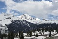
Snowdon Peak from Highway 550
Snowdon Peak from Molas Pass
Snowdon Peak illuminated by moonlight
Snowden Peak to left. West aspect, from near Coal Bank Pass
^Robert F. Rosebrough, The San Juan Mountains: A Climbing & Hiking Guide, Cordillera Press, 1986, page 114.
^John Peel, Paul Pixler, Hiking Trails of Southwestern Colorado, 5th Ed., 2020, West Margin Press, ISBN9781513262987, page 157.
^Peel, M. C.; Finlayson, B. L.; McMahon, T. A. (2007). "Updated world map of the Köppen−Geiger climate classification". Hydrol. Earth Syst. Sci. 11. ISSN1027-5606.
^Rob Blair, Tom Ann Casey, William H. Romme, The Western San Juan Mountains:
Their Geology, Ecology, and Human History, 1996, University Press of Colorado, ISBN9780870813788, page 350.